سوالی دارید ? مطرح بفرمایید
مقالات و نوشتار های تحلیلی
ترکیب 3 تکنولوژی پهپاد، واقعیت مجازی و BIM در کنترل و مانیتور روند پیشرفت پروژه های ساختمانی
ترکیب 3 تکنولوژی پهپاد، واقعیت مجازی و BIM در کنترل و مانیتور روند پیشرفت پروژه های ساختمانی
BENTLEY LINKING AUGMENTED REALITY, BIM AND DRONES
Bentley Systems is looking to combine BIM and augmented reality with drone technology to more accurately capture the progress of a construction project and spot mistakes in the process.
The company recently conducted an experiment around the Bentley office capturing video of the building during the construction of an extension to the second floor.
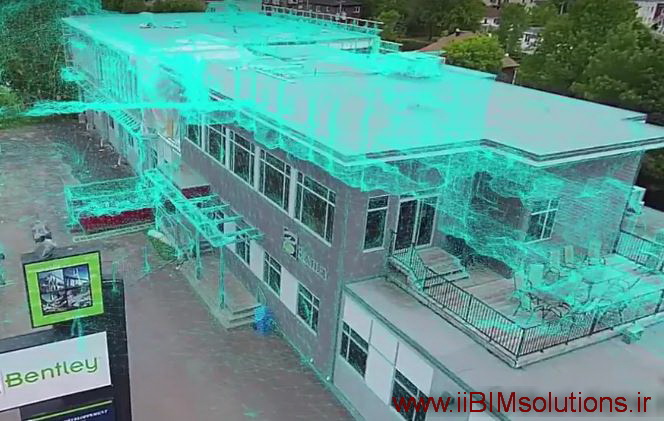
It then extracted all the frames from that video, and used them to create a mesh of the building scene using its own software known as ContextCapture technology. It then aligned the resulting mesh with a BIM model of the building. Finally, it used the calculated positions and orientations of each frame to augment them with the BIM model.
Although the resulting augmentation was not live, and took several minutes to calculate, the company believes such steady augmentation will become a mainstay of the industry and by using drones, camera positions are very accurate and will help with identifying delays or mistakes in the construction process. As technology moves on, the time could also be reduced so that the accompanying video is near or eventually live.
Using standard hand-held augmented reality, you could walk around the site with a tablet and you could view live augmentation of the site which would facilitate the identification of mistakes and delays.
Stephane Cote, research director at Bentley Systems, said that in the future a drone could frequently be flying around a construction site, taking photos, and uploading those to a server on the cloud, which would generate a mesh, align it with the BIM model, and augment the photos with the model.
Cote, said: “The experiment we did on the construction site was basically a research investigation.
“We wanted to see how drone photos and videos are used to monitor construction sites. And it happened that our Bentley building was being renovated, they were adding a new floor on top of the existing one, so it was an excellent site to use.
منبع نوشتار:
http://www.bimplus.co.uk/
